File:Messinian salinity crisis 6 mya stage - last canal.jpg
Jump to navigation
Jump to search

Size of this preview: 800 × 541 pixels. Other resolutions: 320 × 216 pixels | 640 × 433 pixels | 1,024 × 693 pixels | 1,280 × 866 pixels | 2,560 × 1,732 pixels | 3,246 × 2,196 pixels.
Original file (3,246 × 2,196 pixels, file size: 2 MB, MIME type: image/jpeg)
| This free media file is from Wikimedia Commons. Its description page is included below. |
Summary
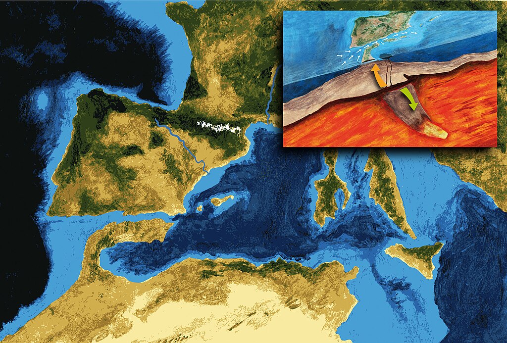
| Description |
Català: Darrera connexió entre l'Atlàntic i la Mediterrània que va sobreviure a l'aixecament de l'Arc de Gibraltar fa 6 milions d'anys. Aquest canal va permetre l'entrada d'aigües atlàntiques que compensaven el dèficit hídric de la Mediterrània que rep menys aigua dels rius de la que evapora la seva superfície. Al mateix temps, aquest flux entrant d'aigua va produir prou erosió perquè el canal es mantingués malgrat el continuu aixecament de la serralada bètica. El tancament de la resta de canals de connexió va causar la hipersalinitat de les aigües mediterrànies i l'inici de la Crisi Salina del Messinià. La vinyeta mostra l'aixecament de l'Arc de Gibraltar entre la zona bètica i la del Rif. També mostra com una part de l'escorça es subsumeix en el mantell mentre part del magma més fos puja per esquerdes en l'escorça.
Interpretació artística realitzada per Pau Bahí amb la supervisió científica de Daniel García Castellanos, geofísic de l'Institut de Ciències de la Terra Jaume Almera (CSIC)
Español: Último canal de conexión entre el Atlántico y Mediterráneo que sobrevivió el levantamiento del Arco de Gibraltar hace 6 millones de años. Ese canal permitió la entrada de aguas atlánticas que compensaran el déficit hídrico del Mediterráneo, que recibe menos agua de los ríos de la que evapora en su superficie. A la vez, ese flujo de agua entrante produjo suficiente erosión como para que el canal perviviera pese al continuo levantamiento de la cordillera bética. La clausura de los demás canales de conexión causó la hipersalinidad de las aguas mediterráneas y el inicio de la Crisis Salina Mesiniense. La viñeta muestra el alzamiento del Arco de Gibraltar entre la zona bética y el Rif. También muestra como una parte de la corteza es subsumida en el manto terrestre y una parte del magma fundido sube por las grietas de la corteza.
Interpretación artística realizada por Pau Bahí bajo la supervisión científica de Daniel García Castellanos, geofísico del Instituto de Ciencias de la Tierra Jaume Almera (CSIC)
English: Last canal connecting the Atlantic and Mediterranean which survived the uprising of the Gibraltar Arc 6 million years ago. The canal enabled the entry of Atlantic waters to offset the Mediterranean water deficit, which receives less river water that evaporates from its surface. At the same time, the flow of incoming water erosion produced enough to keep the channel despite the continued rise of the Betic Cordillera. The closure of the other connecting channels caused hypersaline Mediterranean water and the beginning of the Messinian salinity crisis. The inset box shows the rise of the Gibraltar Arc area between the Betic and Rif. Also shown as a part of the crust is subsumed in the Earth's mantle and a portion of molten magma rises through cracks in the crust.
Artistic interpretation by Pau Bahí under the scientific supervision of Daniel Garcia Castellanos, geophysicist at the Institute of Earth Sciences Jaume Almera (CSIC) |
| Date | |
| Source | Own work |
| Author | Paubahi |
| Other versions |
This file was derived from: |
| Other images in the same set |
|


|
This image was provided to Wikimedia Commons as a contribution
from an art & design school thanks to a collaboration between Llotja and Amical Viquipèdia.
|
Licensing
I, the copyright holder of this work, hereby publish it under the following license:
This file is licensed under the Creative Commons Attribution-Share Alike 3.0 Unported license.
- You are free:
- to share – to copy, distribute and transmit the work
- to remix – to adapt the work
- Under the following conditions:
- attribution – You must give appropriate credit, provide a link to the license, and indicate if changes were made. You may do so in any reasonable manner, but not in any way that suggests the licensor endorses you or your use.
- share alike – If you remix, transform, or build upon the material, you must distribute your contributions under the same or compatible license as the original.

|
This is one of the images forming part of the Valued image set: Messinian salinity crisis in the Mediterranean sea on Wikimedia Commons. The image set has been assessed under the valued image set criteria and is considered the most valued set on Commons within the scope:
The Messinian salinity crisis in the Mediterranean sea
You can see its nomination at Commons:Valued image candidates/Messinian salinity crisis. |
File history
Click on a date/time to view the file as it appeared at that time.
| Date/Time | Thumbnail | Dimensions | User | Comment | |
|---|---|---|---|---|---|
| current | 19:57, 1 July 2012 | | 3,246 × 2,196 (2 MB) | Paubahi |
File usage
The following 14 pages use this file:
- Dvdgmz/Workshop/Case studies-cat
- WikiArS/Case studies
- WikiArS/Case studies/ca
- WikiArS/Case studies/de
- WikiArS/Case studies/diq
- WikiArS/Case studies/en
- WikiArS/Case studies/eo
- WikiArS/Case studies/fr
- WikiArS/Case studies/id
- WikiArS/Case studies/pl
- WikiArS/Case studies/zh
- WikiArS/Gallery
- WikiArS/Gallery/Mosaic
- Translations:WikiArS/Case studies/4/en
Global file usage
The following other wikis use this file:
- Usage on ca.wikipedia.org
- Usage on es.wikipedia.org
- Usage on fr.wikipedia.org
- Usage on nl.wikipedia.org
- Usage on www.wikidata.org