File:Map Italy around 500 b.C. - Touring Club Italiano CART-TRC-40.jpg
Jump to navigation
Jump to search

Size of this preview: 545 × 600 pixels. Other resolutions: 218 × 240 pixels | 436 × 480 pixels | 698 × 768 pixels | 931 × 1,024 pixels | 1,862 × 2,048 pixels | 6,046 × 6,651 pixels.
Original file (6,046 × 6,651 pixels, file size: 4.22 MB, MIME type: image/jpeg)
| This free media file is from Wikimedia Commons. Its description page is included below. |
Summary
| Title |
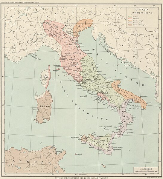
Italy around 500 B.C. |
|
| Description |
English: The map shows Italy around 500 B.C., when it was populated by Italics, Etruscans, Venetians and Iapigis, Greeks, Phoenicians and Carthaginians. The map is one of the tables made by the TCI Cartographic Office for the Italian Encyclopedia of Giovanni Treccani Institute Italiano: La mappa mostra l'Italia intorno al 500 a.C., quando era popolata da Italici, Etruschi, Veneti e Iapigi, Greci, Fenici e Cartaginesi. La mappa è una delle tavole realizzate dall'Ufficio Cartografico del TCI per l'Enciclopedia italiana Giovanni Treccani |
|
| Date | between 1928 and 1940 | |
| Permission (Reusing this file) |
|
|
| Geotemporal data | ||
| Date depicted | B.C. | |
| Map location | Italy | |
| Map type | Maps showing history | |
| Scale | 1: 5 000 000 | |
| Georeferencing | If inappropriate please set warp_status = skip to hide. | |
| Bibliographic data | ||
| Printed by |
Vallardi |
|
| Archival data | ||
| Accession number |
CART.TRC.40 |
|
Licensing
File history
Click on a date/time to view the file as it appeared at that time.
| Date/Time | Thumbnail | Dimensions | User | Comment | |
|---|---|---|---|---|---|
| current | 14:28, 19 October 2022 | | 6,046 × 6,651 (4.22 MB) | Marta Arosio (WMIT) | Cropped 13 % horizontally, 11 % vertically using CropTool with lossless mode. |
| 12:58, 13 October 2022 |  | 6,945 × 7,495 (5.35 MB) | Ilaria Parma (TCI) | pattypan 22.03 |
File usage
The following 2 pages use this file:
Global file usage
The following other wikis use this file:
- Usage on en.wikipedia.org
- Usage on it.wikipedia.org
- Usage on www.wikidata.org