File:Map The Acropolis of Athens and its slopes 1928-1940 - Touring Club Italiano CART-TRC-37.jpg
Jump to navigation
Jump to search

Size of this preview: 800 × 580 pixels. Other resolutions: 320 × 232 pixels | 640 × 464 pixels | 1,024 × 743 pixels | 1,280 × 929 pixels | 2,560 × 1,857 pixels | 8,279 × 6,007 pixels.
Original file (8,279 × 6,007 pixels, file size: 31.78 MB, MIME type: image/jpeg)
| This free media file is from Wikimedia Commons. Its description page is included below. |
Summary
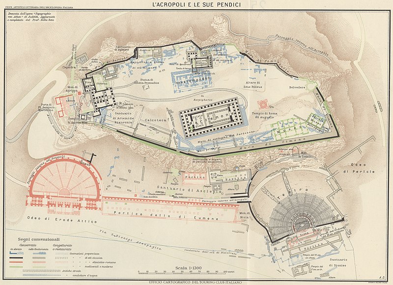
| Title |
The Acropolis of Athens and its slopes |
|
| Description |
English: The map shows the Acropolis of Athens and its slopes, giving additional information about the state of conservation of the buildings and their different architectural styles. It derives from Judeich's"Topographie von Athen" and it was updated by Professor Della Seta. The map is one of the tables made by the TCI Cartographic Office for the Italian Encyclopedia of Giovanni Treccani Institute Italiano: La mappa mostra l'Acropoli di Atene e le sue pendici, dando informazioni riguardo lo stato di conservazione dei diversi monumenti che compongono il complesso archeologico e il diverso stile architettonico che li contraddistingue, correlato al periodo in cui vennero costruiti. Derivata dalla "Topographie von Athen" di Judeich, con aggiornamenti a cura del Professor Della Seta. La mappa è una delle tavole realizzate dall'Ufficio Cartografico del TCI per l'Enciclopedia Italiana Giovanni Treccani |
|
| Date | between 1928 and 1940 | |
| Source | Scan from the original work Archivio Storico del Touring Club Italiano | |
| Permission (Reusing this file) |
|
|
| Geotemporal data | ||
| Map location | Greece | |
| Map type | Maps of archeological sites | |
| Scale | 1: 1 300 | |
| Georeferencing | If inappropriate please set warp_status = skip to hide. | |
| Bibliographic data | ||
| Part of the series | 1° Edition Italian Encyclopedia Giovanni Treccani | |
| Language | Italian | |
| Place of publication | Milan | |
| Publisher |
TCI |
|
| Printed by |
Vallardi |
|
| Archival data | ||
| Collection | ||
| Accession number |
CART.TRC.37 |
|

Licensing
File history
Click on a date/time to view the file as it appeared at that time.
| Date/Time | Thumbnail | Dimensions | User | Comment | |
|---|---|---|---|---|---|
| current | 07:13, 18 October 2022 | | 8,279 × 6,007 (31.78 MB) | Marta Arosio (WMIT) | Cropped 8 % horizontally, 16 % vertically using CropTool with lossless mode. |
| 12:58, 13 October 2022 |  | 9,048 × 7,153 (18.31 MB) | Ilaria Parma (TCI) | pattypan 22.03 |
File usage
The following 2 pages use this file:
Global file usage
The following other wikis use this file:
- Usage on az.wikipedia.org
- Usage on en.wikipedia.org
- Usage on fr.wikipedia.org
- Usage on it.wikipedia.org
- Usage on mk.wikipedia.org
- Usage on ru.wikipedia.org
- Usage on zh.wikipedia.org