File:Regional Ambassadors Map.png
Jump to navigation
Jump to search

Size of this preview: 800 × 495 pixels. Other resolutions: 320 × 198 pixels | 640 × 396 pixels | 1,024 × 633 pixels | 1,280 × 792 pixels | 2,000 × 1,237 pixels.
Original file (2,000 × 1,237 pixels, file size: 256 KB, MIME type: image/png)
| This free media file is from Wikimedia Commons. Its description page is included below. |
| Description |
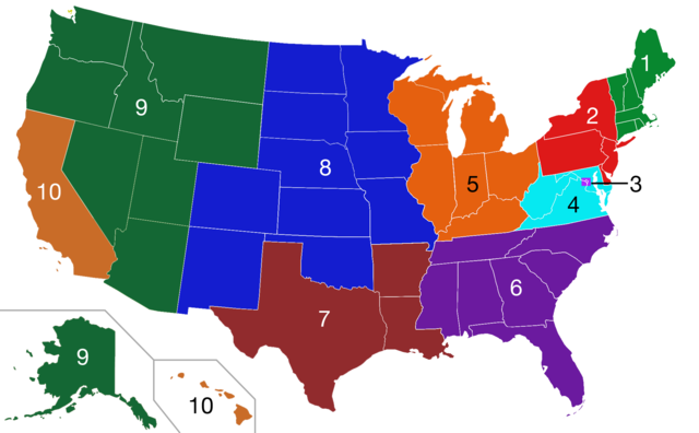
A map showing the different regions a regional ambassador will be in-charge of. Each color is a different region based off this list.
|
| Date | (UTC) |
| Source | |
| Author |
|
| Other versions |
Derivative works of this file: |
| This is a retouched picture, which means that it has been digitally altered from its original version. Modifications: Added color. The original can be viewed here: Blank US Map.svg:
|
This file is licensed under the Creative Commons Attribution-Share Alike 3.0 Unported license.
- You are free:
- to share – to copy, distribute and transmit the work
- to remix – to adapt the work
- Under the following conditions:
- attribution – You must give appropriate credit, provide a link to the license, and indicate if changes were made. You may do so in any reasonable manner, but not in any way that suggests the licensor endorses you or your use.
- share alike – If you remix, transform, or build upon the material, you must distribute your contributions under the same or compatible license as the original.
Original upload log
This image is a derivative work of the following images:
- File:Blank_US_Map.svg licensed with Cc-by-sa-3.0-migrated, GFDL
- 2009-11-05T19:44:02Z NuclearVacuum 959x593 (91518 Bytes) minor fix from previous upload
- 2009-11-05T19:39:42Z NuclearVacuum 959x593 (88399 Bytes) Fixed up the borders so they are connected with each state and loosing that gap between them.
- 2008-10-09T16:36:40Z Howcheng 959x593 (80121 Bytes) Reverted to version as of 08:32, 14 June 2007
- 2008-03-12T00:20:02Z AMK1211 959x593 (174744 Bytes) Added borders: Light blue for water borders and black for land borders (international borders thicker).
- 2007-06-14T08:32:47Z Fibonacci 959x593 (80121 Bytes) Optimised code.
- 2006-07-12T23:00:30Z Theshibboleth 959x593 (90537 Bytes) The line framework around Alaska and Hawaii has been pushed a bit
- 2006-07-12T06:35:19Z Theshibboleth 959x593 (89828 Bytes) added DC
- 2006-07-12T06:05:05Z Theshibboleth 959x593 (89649 Bytes) {{Information |Description=A blank map of the United States in scalable vector form. |Source=Own work, based on [[:Image:Electorial map.svg]], inspired by [[:Image:BlankMap-World.png]] |Date=11 July 2006 |Author=[[User:Theshi
Uploaded with derivativeFX
File history
Click on a date/time to view the file as it appeared at that time.
| Date/Time | Thumbnail | Dimensions | User | Comment | |
|---|---|---|---|---|---|
| current | 03:34, 8 July 2011 | | 2,000 × 1,237 (256 KB) | Manumitany | Reverted to version as of 03:32, 8 July 2011 |
| 03:33, 8 July 2011 |  | 2,000 × 1,237 (256 KB) | Manumitany | As per the Regional Ambassador Training and discussion among ambassadors, the Great Lakes & Non-Contiguous Region (including Hawaii and Alaska) have been divided up. North and South California have been combined. Regions have been re-numbered. | |
| 03:32, 8 July 2011 |  | 2,000 × 1,237 (256 KB) | Manumitany | As per the Regional Ambassador Training and discussion among ambassadors, the Great Lakes & Non-Contiguous Region (including Hawaii and Alaska) have been divided up. North and South California have been combined. Regions have been re-numbered. | |
| 19:41, 7 July 2011 |  | 2,000 × 1,237 (243 KB) | Manumitany | Updated Regions 9 & 10 to new configuration; consolidated Regions 11 & 12 as per new configuration. | |
| 22:49, 27 March 2011 |  | 2,000 × 1,237 (237 KB) | Guerillero | Darkening region 7 per fletch's request | |
| 02:56, 24 March 2011 |  | 2,000 × 1,237 (237 KB) | Guerillero | Added numbers and improved colors | |
| 00:23, 24 March 2011 |  | 2,000 × 1,237 (220 KB) | Guerillero | {{Information |Description=A map showing the different regions a regional ambassador will be in-charge of. Each color is a different region based off this list. *'''Region 1 (Northeast):''' Maine, Vermo |
File usage
The following 4 pages use this file:
Global file usage
The following other wikis use this file: